By Richard C. Hoagland
© 2014 The Enterprise Mission
At the very end of 2013, the People's Republic of China set in motion developments with the power to ultimately ... finally ... change the world.
On December 14, 2013, the Chinese government continued -- with the assistance of "Chang'e," the mythological Chinese "Goddess of the Moon" (and her pet white rabbit, "Yutu") -- a geopolitical mission that began over a half-century before ... poised now to finally reveal to an astonished planet "what's REALLY waiting on its Moon ...."
This is the revolutionary climax to a story that actually began with President John F. Kennedy's unprecedented call in the early 1960's for the United States to be the first to "land a man on the Moon ... and safely return him to the Earth ..." within ten years, a NASA project that would soon be known to all the world by a single name, "Apollo."
What NASA (through its Apollo Project) actually discovered on the Moon, beginning just seven years later, has now been resoundingly confirmed (if not yet "officially" announced ...) by the Chinese "Chang'e-3" unmanned lunar landing mission--
A stunning validation of not only the ultimate reality of "the Apollo Program" itself (against all those who have claimed, against overwhelming evidence, that "it never really happened ...") -- but what the Apollo astronauts actually found ... all those years ago -- which NASA then inexplicably, but relentlessly, suppressed:
The still-glistening, crystalline remains of "an extraordinarily ancient, Type II lunar civilization."
Now, the Chinese government -- almost a half-century after the American astronauts first quietly recorded them -- has just as quietly published official ... independent ... stunning Chang'e-3 color images--
And, we have 'em.
 
* * *
This a story best understood chronologically ....
On December 14, 2013, the Chinese National Space Administration (CNSA), after orbiting two successful unmanned lunar reconnaissance missions some years earlier -- "Chang'e-1" (in November, 2007), and "Chang'e-2" (in October, 2010), made its third unmanned lunar mission -- to land on the surface of the Moon, in the northern region of an ancient lunar "sea" known as Mare Imbrium ("the Sea of Rains" - below) -- look deceptively "easy" ... at 9:11 PM Beijing Time (13:11 UTC).

A 2600-lb robotic spacecraft, named "Chang'e-3" (again, after "the Chinese Goddess of the Moon"), for the first time in 37 years (since the Soviet Union's Luna 24, in 1976) touching down in the northern part of Mare Imbrium -- carrying, as a BONUS, China's first "autonomous lunar rover," a 312-lb, six-wheeled, solar powered vehicle named "Yutu" ... Chinese, for Chang'e's famed mythological lunar companion, "Jade Rabbit"; many Asian cultures, when they look at the Moon, do NOT see a "man in the Moon" in the darker outlines of the waterless lava plains (termed "seas" by earlier observers), but the outline of a "Rabbit" ... hovering over his "morter and pestle, forever compounding his elixir of immortality" on the face of the Full Moon (below).

The scientific instruments carried by this first-time Chinese lunar landing -- on both "Chang'e-3" and "Jade Rabbit" -- were impressive ... and revealing:

From multiple, high-resolution CCD television cameras on both spacecraft (B&W and color); to the first "working" astronomical observatory on another world (a remotely-operated UV telescope on the Chang'e-3 Lander); to a sophisticated ground penetrating radar system (GPR) on Chang'e's "pet rover," Yutu -- the Chang'e-3 Mission Designers had successfully placed a suite of highly-capable, complex scientific instruments on the surface of the Moon on their first attempt.
This array of instruments, which could relay back the broadest range of early scientific information relevant to not only the Chinese government's stated objectives for the Chang'e-3 Mission -- "SURVEYINGthe moon’s geological structure and composition to locate the moon’s natural resources for use by potential future Chinese astronauts ..." -- but instruments also capable of confirming, if not answering, many crucial questions about the "unspoken subject" looming over the entire Chang'e-3 lunar mission--
The still unacknowledged presence -- even after ~50 years -- of bona fide "ancient, ET structures on the Moon ...."
* * *
With this as prologue, we at Enterprise watched with eager anticipation (and not a few twinges of nostalgia ...) the Chinese "wall-to-wall" media coverage of their first unmanned extraterrestrial landing -- in the pre-dawn hours (Mountain Time) of December 14, 2013 -- vivid memories of our own first-hand experience with the first US unmanned lunar landing (Surveyor I - in the summer of 1966) still indelibly printed on our mind; we had been in New York City that first day of June, all those years ago in 1966, "playing tourist" with a long-time high school friend (which included a spur-of-the-moment visit to the NBC television studios at Rockefeller Center), when Dr. Frank Field had suddenly "drafted" me -- as "Curator of Astronomy and Space Science, at the Springfield Museum of Science ..." -- to assist him in NBC's planned LIVE TV coverage, in the wee hours of June 2nd, of Surveyor I's just hours-away historic landing on the surface of "Oceanus Procellarum!"
Watching the live Chinese TV and Internet coverage of Chang'e-3's landing, 47 years after that historic night in 1966 -- interspersed with parallel international "space community" web postings and live comments-- brought all the excitement of that distant Surveyor I experience flooding back (which you can also share, preserved in this vintage BBC audio recording of that amazing early June morning, thanks to Peter Burton in the UK...) -- even as the Chang'e-3 robotic lunar spacecraft deftly arced out of its low orbit of the Moon, almost a half-century later--
To a perfect touchdown on Mare Imbrium's northern plain ....

If you noticed something slightly "wrong" with the above graphic -- the last-minute change of landing site -- CONGRATULATIONS; the first indication for Enterprise that the Chinese might be "up to something ... interesting" ... with Chang'e-3, came days before this totally unannounced, "last minute" landing site switch ... in a casual look at the official Chinese government media "Chang'e-3 website"(below).

Can you spot the strikingly familiar feature (certainly to all long-term readers of Enterprise ...) that really makes one take a startled "second look" at this particular website?--
And ask:
"Why THAT specific symbolism ... on a nominal, unmanned, Chinese lunar mission?"
This, in case you missed it, is what we're referring to (below):

What was an obvious tetrahedron (in fact, two -- counting the "perspective view" just to the right on the Chinese web page) -- the geometric centerpiece of our entire Enterprise MissionHyperdimensional/Torsion Physics Model ... having NOTHING to do, in ANY logical fashion, with "an unmanned robotic landing on the Moon"--
Doing on the official Chang'e-3 Mission media website?!
It would only be a matter of days, as Chang'e-3 successfully arced down -- NOT in the "previously planned and widely publicized" lunar landing site, in Simus Iridum ... the "Bay of RAINBOWS ... but hundreds of miles to the East, in Mare Imbrium -- that we would finally know ....
* * *
For those who have forgotten just how important a "tetrahedron" truly is -- symbolizing an entire field of "suppressed science" per our ~decades-long, Enterprise milti-disciplinary investigations of "Hyperdimensional Physics" -- here is a quick refresher (a much more comprehensive explanation can be found here, and in Chapter 2 of "Dark Mission: the Secret History of NASA"):
What Enterprise has confirmed over the last ~two decades of these investigations, is an empirical, geometric surface pattern of "planetary/stellar energy upwillings" ... all across this solar system ... and beyond -- which are PREDICTED by the simple matching of those observed energy disturbances against an interior geometric planetary/stellar model; that model incorporates a virtual "tetrahedron-inside-a-circumscribing sphere standing wave energy pattern" ... to predict the "hyperdimensional energy production/distribution" within a given planet/star ....
The prime planetary example of this "standing-wave tetrahedral geometry" in this solar system:
Jupiter.

For over four hundred years, the enormous, planet-sized vortex in the southern hemipshere of Jupiter's vast, roiling atmosphere -- a swirling giant atmospheric reddish oval, known as "the Great Red Spot" (GRS - below) -- has been a baffling solar system enigma; likened by early astronomers to "a terrestrial super-hurricane," the GRS' sheer existance on a planet ~5 times farther from the Sun than Earth, and thus with atmospheric energy inputs from the Sun at least 25 times smaller, coupled with the GRS' extraordinary persistence over centuries ... even in the face of intense "dissipative forces" from Jupiter's highly turbulent, surrounding atmosphere ... have posed fundamental hydrodynamic problems for all planetary theorists seeking to "conventionally" explain the GRS' formation and existence ... let alone, in stark contrast to thermodynamically (heat)-driven terrestrial hurricanes ... its apparent "immortality," even in Jupiter's super-cold surrounding planetary atmosphere ....

Adding to the mystery, this giant planet -- ~10 times the diamater of Earth, with a mass over 300 times our planet ... and spinning a little over twice as fast -- appears, in the words of one astronomer many years ago, "more like a failed star ... than a conventional planet."
This, because -- to everyone's surprise -- Jupiter was discovered, in the 1960's, to be radiating not quite twice as much energy (heat) into space every second ... than it receives from the Sun half a billion miles away!; soon, all the "giant, outer planets" -- Jupiter, Saturn, Uranus and Neptune, to widely varying degrees -- were confirmed to be radiating more internal energy into space ... than they each received (as infrared and visible light electromagnetic radiation) from the Sun itself.
"HD Physics" operates on the fundamentally different tenet from these previous theories, that the energies driving Jupiter (and later, it turned out, ALL the so-called "giant planets"), are NOT coming externallyfrom the star (the Sun) located at the center of the solar system ... or ... from "internal core radioactive decay "... but stem from "hyperdimensional/torsion field energy transfer" INTO the planet--
From other "spatial 'hyper-dimensions.'"
A dimensional energy transfer (in the model), driven by a combination of the giant planet's mass ... coupled ... with its high-speed rotation/precession.
The Enterprise "Hyperdimensional/Torsion Field Model" not only accounts for Jupiter's observed "anomalous energy output" (as energy is transferred, via Jupiter's massive rotational angular momentum,into Jupiter from this "other spatial dimension" ...), the Model also predicted that, if this transfer were occurring, the asociated torsion field forces, acting on the visible atmosphere, must also leave an unmistakable HD/torsion field geometric signature" in Jupiter's vast, rapidly rotating atmosphere--
A gargantuan atmospheric vortex--
Coalesced ... "tetrahedrally" ... at 19.47 degrees (usually "rounded up" to 19.5) south (the southern hemisphere location determined by the opposite polarity of Jupiter's internal magnetic field compared to Earth's).
A pinned "forever storm" the size of three Earths ... spinning eternally over one of the four vertices of an internal "torsion-wave tetrahedron ..." -- aligned, by virtue of Jupiter's rotation, with the planetary spin axis (below) ....

Where the Great Red Spot has been endlessly ... tetrahedrally ... spinning--
For at least 400 years.
As noted earlier, Jupiter is NOT the only "giant outer planet" observed to be radiating more energy into space than it receives from the Sun; Saturn is even more dramatic in this regard -- radiating well over twice as much internal energy as it receives.
But, even more dramatic, Saturn exhibts a totally different Hyper-dimensional/Tetrahedral signature in its upper atmosphere, compared to Jupiter -- independently (in addition to the internally radiated energy ...) indicative of its own, unique internal "standing wave" hyperdimensional energy dynamic--
A stunning, visible atmospheric "polar hexagon" (below - left - right) appearing in Saturn's northern hemisphere -- apparently mirroring, in Saturn's upper-level frozen ammonia clouds, forever circling the northern pole, the larger, deeper, internal "double standing-wave tetrahedral energy pattern" (graphic - bottom) -- wrapped (in the model ...) around the exact rotational axis of the planet!

What makes Saturn even more "unique" -- in allowing us to track down this source of apparent "overunity" internal energy generation/radiation in all the "gas giants"-- is the fact that we finally have a long record of Saturn's "anomalous, excess-energy emission" fluctuations, acquired over several years, to analyze--
Measured directly from Saturnian orbit.
From the US Cassini unmanned spacecraft, at Saturn since 2004, NASA has been able to record over the last ten years -- with unprecedented precision -- these crucial Saturnian "anomalous HD energy vaiations" up-close; amazingly, when these Saturnian "overunity energy emissions" from Cassini are carefully analyzed, the internal excess energy emissions turn out to be asymmetric inside Saturn; the northern hemisphere -- the one with the bizarre "giant, geometric hexagon" -- is also (as a direct effect?) radiating ~17 % less energy into space, when compared to Saturn's southern hemisphere ... where a totally different"atmospheric geometric signature" is also visible, circling that pole--
A huge, planet-sized "permanent hurricane" (also called "the south polar vortex" - below - right) ....

Cassini's long-term, close-in infrared measurements of Saturn's "internal IR excess," mirrors earlier measurements made with Earth's largest ground-based telescope, at the Keck Observatory on Hawaii, in 2005; a Keck long-wave IR Saturn image (below - right) is independently verified by Cassini's later, independent, much higher-resolution IR atmospheric heat measurements (below - left).

Confirming that, where on the planet the "south polar vortex" is hemispherically centered (exactly on the planet's rotational axis ...), coincides exactly with the visible peak of Saturn's global, internal IR energy emissions!--
The obvious result of the "internal, geometric generation and control" of Saturn's "HD/torsion field" energy source ....
All "conventional" known planetary energy reserves -- primordial storage of planetary heat from Saturn's ancient formation; the presence of internal nuclear fission decay sources; gravitational "shrinkage" and conversation of that planetary potential energy into internal kinetic energy (heat); even "gravitational separation" (rain) of some elements (helium) from the overlying material (hydrogen) inside Saturn, releasing frictional energy (heat) -- could NOT ACCOUNT
Its unique, geometric radiation pattern ... and, its (now) confirmed variance with time ....
Not only did the "hyperdimensional energy generation" within Saturn leave radically different atmospheric "surface" cloud-geometries in its two separate, global hemispheres (as the internal energy directionallyescaped ...) -- it also left a unique "absolute brightness [temperature] signature" in each respective hemisphere, to independently mark the energies' assymetric generation and release ... as well as its "synchronized" change in absolute and relative brightness over time--
With the observed radiated energy from Saturn being amplified almost 20 percent more in the southern hemisphere ... compared to the north; all conventional energy sources, by stark contrast, would release their stored internal energy inside Saturn--
Symmetrically.
And, equally important:
Evenly ... over time.
The astrophysical implications of this "assymetric ... waxing and waning ... internal HD-energy-generation pattern" -- for Galactic objects far more massive than "Jovian-type planets" -- were now also obvious--
Starting with the Sun.
* * *
The Sun (like the majority of similar stellar-massed objects ...) undergoes its own periodic (if very slight -- ~0.1 percent) variation in internal energy production, termed "the Solar Activity Cycle"; while too small to have a significant short-term effect on Earth's overall temperature and climate, one visible indicator of this very subtle solar energy varation came from early observers watching the regular appearance and disappearance of a series of "blemishes" on the surface of the Sun--
Called "sunspots."

The irony, of course, is that it was the Chinese who left us the earliest written records, around 800 BC, of seeing "dark spots on the surface of the Sun."
It wasn't until the 19th Century (AD), however, that astronomers finally realized (from examination of European sunspot records extending back through the Middle Ages ...) that there was a remarkable (if totally mysterious) "periodicity" to the appearance and disappearance of these dark "solar apparitions" ... resolving to an average "sunspot cycle" period of ~11 years (below) ....

They also noted that, for equally unknown reasons, not all sunspot cycles were "created equal" (above); some (later termed "large cycles") consisted of a LOT of spots, covering significant solar surface areas; others (termed "small cycles"), contained relatively few spots in the cycle ... and those tended to occupy smaller areas when they appeared.
But it wasn't until the early part of the 20th Century, when George Ellery Hale, almost single-handedly, created the entire modern edifice of "astrophysics" -- built on his own unprecedented solar measurements of these cyclically-appearing "dark solar vortices" ... their composition ... their recurring patterns and rotations ... and their intense magnetic influence on the rest of their solar "photosphere" surroundings -- that science would even begin to understand the role of these "mysterious surface vortices" in marking the much deeper, invisible source and flow of the Sun's fundamental, internal energy production--
The same energy, Hale's measurements would eventually reveal ... that powers the entire nightime sky ....
In the mid-20th Century, after Hiroshima (leading inevitably to the "H-bomb" ...), astrophysicists would suddenly proclaim (despite major "dissenters" -- like Russian astrophysicist, Nikolai A. Kozyrev), that--
The crucial, unknown "ultra-long-lived stellar energy source" operating inside all stars was--
Thermonuclear ....
Meaning ... it was the fusion of light elements together (hydrogen, helium, lithium, etc.) into heavier ones (carbon, nitrogen, magnesium ...), deep in the stellar interiors, that ultimately--
"Lights the stars."
Based on our ~30 years of independent astrophysical investigations, we have come to a radically different conclusion--
Kovyrev was right!
"Hyperdimensional energy" (he called it by a different term ...) -- NOT "nuclear fusion" -- is the primary energy "that fuels the Universe" ....
The breakthrough that allowed us to come to this (highly controversial ... even if eminently testable) conclusion:
The demonstrable "tetrahedral" link -- between the excess, hyperdimensional energy being generated in all the solar system's giant outer planets, and an identical (if much larger) solar energy source -- revealed via this same "tetrahedral" signature geometry, determining the latitude placement of active solar regions" ... including sunspots ... with the changing solar cycle.
That crucial "hyperdimensional solar connection" was our discovery that -- averaged across literally thousands of world-wide, sunspot and solar cycle observations, gathered by hundreds of astronomers over the past 137 years -- the average solar latitude of recurring, peak "solar maximum" activity (below) was--
19.5 degrees!

Bingo!
Visual confirmation of this amazing solar "hyperdimensional correlation" can easily be seen in NASA's latest solar observations; this TRACE satellite image (below), taken during a recent "solar maximum," optically confirms the extraordinary, geometric match (above) of the dual latitude, energetic solar activity to our "double-tetrahedron, hyperdimensional model" -- encompassing simultaneously both solar hemipsheres ....
At ~19.5 degrees!

Needless to say, such a radical "stellar/planetary energy alternative" is going to revolutionize not only how we understand the Universe ... but, ultimately, how we power our own Civilization--
Replacing, to begin with, all currently disastrous fossil-fuel consumption -- with ultra-clean ... limitless ... "hyperdimensional/torsion field energy technology" ....
* * *
To find redundant examples of this unique hyperdimensional energy signature -- a "tetrahedron" ... outlined specifically in "tell-tale, energy-emitting stars" -- on an official Chinese website supposedly devoted solely to posting "the technical aspects and progress of the Chang'e-3 lunar Mission"--
Immediately raised profound and telling questions ... about the real objective of the entire Chinese mission ....

Like--
Was "someone" in the Chinese government (which, of course, controls ALL broadcast and Internet media in China) sending a tetrahedrally-coded message to "someone else " ... NOT in China?
That -- in addition to its much publicized conventional lunar research -- the Chang'e-3 Mission was also secretly intending to explore the hyperdimensional energy physics--
Of the Moon?!
Remarkably enough, an extraordinary opportunity for the Chang'e-3 mission to do just that is presented by the April 15, 2014 total lunar eclipse -- which, seen from the Moon -- is, of course--
A total eclipse of the Sun.
By their unique positions -- being on the Moon during the eclipse (which also coincides with the current "Mars Opposition" window) -- both Chang'e-3 robots will have an unparalleled opportunity to redundantlymeasure the "HD/torsion-field" effects of a dual solar eclipse/planetary alignment ... as observed directly from the surface of another world (below)--
To, in turn, compare with our own Enterprise Mission HD/Torsion Field Eclipse Results -- acquired during the May 20, 2011, Annular Solar Eclipse ....

Or ... even more intriguing ... was China clandestinely intending to explore possible, ancient "hyperdimensional technologies" ... present on the lunar surface ... left in the "ancient lunar ruins" (we have been presenting evidence supporting, now, for decades) -- ruins potentially abondoned by the Type II Civilization that (our decades of research has led us to believe ...) built those long-shattered, "ancient lunar crystal cities" ... millions of years ago?
Or--
Was this obviously (now) coded, tetrahedral message -- on the official Chang'e-3 website -- telling that same "someone else," that China was intending to do both ...?
And then--
Planning to make this stunning lunar ET/hyperdimensional technology public?
If so, it would be THE "game changer" of all history ....
Unless ... there was an alternative scenario--
Some, equally-secret, terrestrial geopolitical demand (that China was making to that "someone else," behind-the-scenes ...) was the actual objective.
To be blunt:
Was China actually trying to "blackmail" the West ... into "doing something" here on Earth that the West doesn't want to do ... with a "threat" of exposing on the Moon "what the West has done everything to keep suppressed ... for over 50 years?"
Can you say (in Mandarin ...) "high-stakes poker?"
* * *
One of the other, early clues -- that "something unusual was going on" around this historic China lunar mission -- lay in one of the most mundane details:
Just where on the Moon Chang'e-3 planned to actually land.
Despite exhaustive pre-launch publication of a wide variety of technical details (as measured against previous Chinese space missions ...) regarding the impending Chang'e-3 unmanned lunar landing -- from detailed engineering design of the two spacecraft themselves, and their respective complement of seven separate scientific instruments; discussion of planned geological site characterizations, descriptions of planned lunar surface operations -- including, first time lunar surface astronomical research -- as well as intended surface elemental composition analysis; even, a detailed SURVEY
And, as you can see from the high-resolution (~1.5 meters/per/pixel) mapping of potential landing sites in Sinus Iridum by the previous Chinese lunar reconnaissance mission -- Chang'e-2 (below) -- "Sinus Iridum," as the announced "destination," was a VERY large target area indeed ....

For some reason, despite all the media hoopla and national excitement around their first unmanned lunar landing ... before Chang'e-3 actually set down, the Chinese were obviously NOT willing to inform the world of its MOST elementary ... if not geologically important fact:
Their specifically intended exploration site.
The reason for this peculiar (and, highly unscientific) "political" Chang'e-3 decision would soon become blatantly obvious ... but only after Chang'e-3 successfully touched down -- a full orbit "early" (compared to official Chinese pre-landing announcements, made just days before) ... and hundreds of miles east of "Sinus Iridum"--
In northern Mare Imbrium ("the Sea of Rains").
At--

~19.5 West ... ~44 North!
The actual Chang'e-3 touchdown longitude, corresponding (within 0.01 degrees) ... eerily ... impossibly ... to the crucial "hyperdimensional, inscribed tetrahedral angle" -- echoed by the posting of twotetrahedrons on the official Chang'e-3 website ... months before!

Obviously -- from this statistically "impossible" (but factually, now unquestionable) Chinese tetrahedral redundancy -- the entire Chang'e-3 mission had to have been designed specifically around some aspect of this uniquely specific "tetrahedral code"--
Carefully kept secret -- until "the last possible minute ..." -- as Chang'e-3's repetitive, ~2-hour polar orbit of the Moon ... initially established December 6, finally, on December 14th ... took it directly over the "secret" Mare Imbrium future touchdown location (below)--
At -- 19.5 West.

So--
What was located there -- at "19.5 West, 44 North" -- that Chang'e-3 (from all the accumulating evidence) was intending ... all along ... to FIND?
And ... how?
* * *
A few hours after landing, when the first Chinese post-landing image from the Cheng'e-3 Lander is telemetered back from the surface of the Moon, the "curious" method the Chinese government chooses to release this "historic image," further reinforces our now well-developed Enterprise suspicion that "the Chinese are definitely ... but artfully" ... trying to hide something--
At ~19.5 degrees.
By pretending to "operate a 'normal' geological mission to the Moon" ... while actually, carrying out a clandestine "parallel reconnaissance mission" of something else ... located at those specific, incredibly significant "tetrahedral" lunar coordinates--
Just like NASA's on-going, clandestine Curiosity Rover Mission -- to Gale Crater, on Mars.
Case in point:
Instead of the standard, 21st Century international "norm" for spacecraft image distribution -- space agency-processed digital images (and video) made freely available on official space agency websites, to bedigitally downloaded by local and global media outlets (and "ordinary folks" around the world ...) -- the first Chang'e-3 lunar surface scene is projected by a television system in the Beijing Control Center, on a large electronic viewing screen up front (below); only select Chinese media are then allowed to video (and, only video) that screen ... and then, only with commercial grade television cameras--
This was how the world was introduced to China's first historic Chang'e-3 images ... acquired on the surface of the Moon ....

Some way to treat "history" ... eh?
The resulting "copies ... of a copy ... of a copy" shown on Chinese television, and subsequently copied on all the official Chinese websites, was just about what you'd expect from such a deliberately clumsy "Rube Goldberg" process--
A deliberately degraded -- if "historic" -- first Chinese Chang'e-3 image (below)!

Acquired by one of three wide-angle engineering ("monitor") cameras on the Lander immediately after touchdown, despite the less-than-optimum "screen grab" Chinese media presentation, among the remarkable details visible in this first image were a collection of attention-grabbing, "anomalously reflective" rocks -- lying around the rim of a heavily-eroded, ancient impact crater located just a few feet north of theChang'e-3 touchdown point; attention-getting for a) their strikingly angular "geometry," and b) their remarkable blue tint ... contrasting sharply with the equally anomalous "reddish brown" of the surrounding lunar surface.
These obvious brightness anomalies and equally anomalous colors on the first Chang'e-3 images, raised immediate questions in the minds of many observers, regarding "how accurate" a representation of the Mare Imbrium lunar surface this truly was -- when compared to the essentially colorless lunar surface seen on all the Apollo film photography, of decades earlier (below) ....

But to Enterprise, what was most remarkable -- given that similar-looking Chang'e-3 images were soon coming from more than one camera on the Lander, thus, pretty much ruling out "gross miscalibration"between cameras -- was the striking "angular, 'geometric' nature" of those peculiar bluish rocks (below).

To any "selenologist," this remarkable angularity immediately implied "recent" geological origins ....
The paradox being--
The crater these objects had obviously been ejected from (because they were lying on its rim ...) -- as judged by its overall, heavily-degraded appearance -- seemed, by comparison, much OLDER than the rocks themselves.
So, how could such young "ejecta" (as such impact-excavated, underlying fragments are called) -- exposed by the same explosive impact event that had created the crater itself -- be so much younger (far less eroded ...) than the morphology of the crater that created them?!
The only answer to this paradox that made any scientific sense, was that this particular crater (about 60 feet across ...) had formed in very "unconsolidated" upper surface materials (the topmost lunar "soil" ... or "regolith," on which Chang'e-3 had landed). Such loose, previously pulvarized material was easily degraded (by on-going, relentless micrometeorite impacts on the airless Moon), in a much briefer period of time, than craters formed in high-strength "bedrock" -- thus, in a relatively few million years, such surface craters could, indeed, APPEAR much "older."
Because the impact north of Chang'e-3 had excavated only part way into this finely-graded, upper lunar surface layer (the loose "regolith" ...), that layer apparently also contained -- like rasins scattered in a rasin bread -- many larger, highly "angular" objects deep within it; it was these previously buried (thus, protected from micrometeorite erosion) "chunks" ... which were subsequently more easily thrown about on the lunar surface by low-energy meteor impacts INTO that loosely-structured surface regolith ....
So, if the "peculiar, bluish objects" lying on the rim of this eroded impact crater were NOT "large, ancient, shattered pieces of the bedrock underlying Mare Imbrium" -- ejected by high-energy impacts penetrating deep beneath this "fluffy" surface layering -- where had these "anomalous blue fragments" actually come from?
And--
What was their real nature ... and their origin?
When examined closely, these increasingly remarkable objects' startlingly straight-edged geometry -- coupled with their equally remarkable blue "translucence" (below) -- suggested an amazing alternative to the typical "excavated bedrock" hypothesis for such crater rim debris--
That these bluish geometric objects were, in fact, remnants of some kind of manufactured glass (below) -- fallen from the "ancient lunar dome" that once stretched over this part of Mare Imbrium ... until ... "recently" excavated from their ancient grave ....

Again -- in the face of such provocative scientific information, revealed in their very FIRST transmitted view from the surface of the Moon ... why would the Chinese want the WORST possible version of this remarkable "first image" (a "screen grab!" ...) to be the officially record of that historic feat!?
Unless --
The Chinese government's prime political consideration was NOT in presenting "the best possible face" on their amazing, "first time out of the box" technical accomplishment ... but (apparently) to totally devalueanything "anomalous" SEEN on that first telemetered image ... scientifically ....
So, if it was ever called as "evidence" -- of something truly "extraordinary" present on the Moon--
The details simply wouldn't/couldn't be believed ....
* * *
After this first "for the record-books" Chinese surface view, the next order of business -- beginning several hours after landing (after remaining on-board fuels had been safely vented from the Lander) -- was "unloading" the Chang'e-3 Rover, "Jade Rabbit"; this operation involved an elaborate, gradual mechanical process of cleverly lowering the ~300-lb Rover about six feet vertically to the lunar surface, on rails (from its stowed, touchdown position atop of the Lander - below) -- culminating in "riding it down" those deployment rails horizontally ... until its six wheels were finally, firmly on the ground.

Again, instead of crisp, properly calibrated digital video of this historic process ... the Chinese mission controllers projected more "grabbed stills" from the Chang'e-3 monitor cameras on their "giant Beijing screen" (below)--

From which Chinese (and eventually, the global) media assembled a series of Gifs into their own "animated video" of this crucial (and engineeringly unique) "rover deployment operation" ....

The next release image taken by Chang'e-3 was acquired by a totally different spacecraft system -- the "landform camera" on the Lander. This was the imaging system which was designed to capture "calibrated"scientific panoramas of Mare Imbrium from Chang'e-3; its resolution and color stability was supposed to be far superior to the Lander "monitor cameras," returning those initial engineering images ....
But again, this (theoretical) major improvement in camera quality was totally wasted ... via the deliberately "peculiar method" Chinese mission controllers had chosen for releasing this entire sequence of "first lunar surface images" to the waiting press--
As another "light scattered ... over-saturated ... image projection" -- on the Beijing Mission Control big screen (below).

Here (below) is a side-by-side presentation of images from the two types of Chang'e-3 cameras -- the first "monitor" camera image (below - left), and the first "landform" camera image (below - right); the yellow outline represents the 18-degree-wide field-of-view of the "'zoomed-in' landform camera, compared to the wider-angle monitor camera view.

Looking at these, again, apparently deliberately degraded Chinese lunar images, I couldn't help but compare this cumbersome (if not fundamentally disingenuous) "Chinese image release system" in 2014, with the almost "stone knives and bearskins" analog imaging technology NASA had to overcome during that historic night in 1966, to bring Americans (and the world ...) their first LIVE Surveyor I television pictures from the surface of the Moon--
With me as a surprising, first-hand witness ....
Even in those crude "analog days," JPL did NOT have NBC simply "point a camera" at the JPL television monitors displaying the lunar imaging data coming in (a BBC audio recording of the reception of that historic first Surveyor I lunar image, as it was transmitted from the Moon early that morning and narrated by "the Voice of Surveyor, Dr. Albert Hibbs," is available here -- again, courtesy of Peter Burton); instead, NASA had all the TV networks at the time (all three of them ...) "hardwired" directly into the JPL electronic "RAMTEK" data display system -- which was simultaneously receiving (and converting -- for closed circuit and broadcast television) those amazing first-time US images from the Surveyor spacecraft--
Via the real-time telemetry link coming into the Goldstone Deep Space Network (DSN) antenna ... from the Surveyor spacecraft's 10-watt S-band transmitter on the surface of Procellarum, "a quarter-million miles away" ....
Of course, we were all so naive back then, in 1966 ... to expect -- and then, to actually receive ... for awhile, anyway -- uncensored NASA lunar images (below)!

But then--
Three years later -- when Apollo 11 landed two Americans for the first time on that same Moon, in a manned lunar spacecraft called the "Lunar Module" (only three years ...) -- NASA responded very differently to the possibility that "Americans might see ... LIVE ... what was really on the Moon"; the Space Agency carefully provided only a single black & white, ~320-line TV camera on that Lunar Module (the analog standard for commercial television at the time being "525 horizontal scan lines" -- so, already, image resolution was seriously being degraded ...); then, the Agency arranged to have only a single (NASA-controlled) "pool feed camera" pointed at a TV screen showing the scenes from that single lunar TV camera -- at the Australian tracking station receiving this Lunar Module transmission that July night -- mechanically converting this "low-resolution, noise-filled, non-standard Apollo lunar surface transmission" into a standard TV signal ... which could then be re-broadcast to the rest of the world (via the world-wide television networks "taking that single NASA' lunar feed" - below).

A single "picture ... of a picture ... of a picture."
Just like the 21st Century Chinese ....
Decades after Apollo, in 2009, when digital video enhancement -- that would have electronically allowed "significant restoration" of what Apollo 11's sole black and white TV camera on the lunar surface actuallysaw (and transmitted to Earth that historic July night) -- was about to be brought to bear upon this original 40-year-old Apollo video data, it was belatedly "discovered" that NASA, sometime in those intervening four decades, had tragically ... conveniently ... "lost the original Apollo 11 video tapes of those historic, one-of-a-kind July 20th transmissions of Neil and Buzz cavorting on the Moon!"
The Chinese, even decades after Apollo, had apparently been paying very close attention to how "an official space agency could appear to broadcast what was on the lunar surface" ... while, at the same time, cleverly concealing (through "plausible image degradation") what its lunar surface cameras were actually seeing.
Only slightly more incongruous than this blatantly "unscientific," NASA-like behavior of the Chinese government -- toward its own "first historic data from the surface of the Moon" (!) -- was the obsequious reaction to this pretty obvious effort to deliberately obscure Chang'e-3 mission details, by many "western science groupies"; public comments, on several well-known "western space websites" trying to follow the details of the Chinese lunar mission, instead of being outraged at the lack of even "the simplest adherence to the historic standards for 'first lunar surface imaging releases' set by NASA with Surveyor I (even while operating under stunningly 'primitive' technological constraints, by comparison)," merely expressed mild "disappointment"--
That, these first historic images ... because of "bad PR advice to the Chinese" ... were being "shot off a screen in Beijing."
One "administrator" even when as far as warning--
And THAT prevailing "space enthusiast" attiitude is a major reason why NASA (and the other, equally less-than-forthcoming national space agencies) have been able to get away with effectivelhy HIDING what is really out there in the solar system ....
Including -- "what's really on the Moon"--
For over half a century!
* * *
Meanwhile, back inside the Beijing Control Center ....
Immediately following the successful deployment of Jade Rabbit, the Chinese plan was for each (now) independent "mooncraft" to take a series of mutual images -- Lander imaging Rover ... Rover imaging Lander -- as Jade Rabbit made a slow half-circle of the Lander (from north to south, in the inverted graphic - below) -- stopping every 60 ("tetrahedral"...) degrees for their respective imaging opportunities, moving from "A" ... to "B" ... to "C," etc.

Here again, projected on the "big screen" in the Control Center (below), was the first landform camera image of Jade Rabbit -- after its short ride down the deployment rails, to its first "turn in place" photo position on the lunar surface ("A") ... a short drive (a few feet) north of the Lander.

And here (below) is the Chinese "grab from the screen" of that historic Yutu image -- representing (again) the "official Chinese release" of the first picture of Jade Rabbit "on its own."

Simultaneously, the Control Center plan called for the shadowed side of the Chang'e-3 Lander (below - left) to also be imaged for the first time ... by Jade Rabbit's own twin "panoramic cameras"--

--until the Rabbit reached position "D" (below) -- where it would be able to image Chang'e-3's prominently-displayed "Chinese national insignia" on the sunlit (south) side of the Lander ....

It was obvious, from the careful Chinese pre-planning of these early Yutu activities (and their apparent determination to follow "at all costs" this previously scheduled set of post-deployment Rover photo operations), that the Beijing controllers apparently had NO "contingency plans" for altering the mission ... to include ANY serendipitous "targets of opportunity."
Like--
Close-up, immediate examination of those extraordinary "geometric lunar rocks" (below) ... just feet away.

Instead, immediately following deployment, the Chinese controllers -- "slavlishly" following their pre-launch plan -- drove the Rabbit, as fast as physically possible on the gently rolling lunar soil ... away from the remarkable "ancient impact crater ... and its potential 'tell-tale rocks'"--
The Chinese flag -- on the opposite side of the Lander from the "rocks"--
In "good lighting!"
Even the previously uncritical "Internet space watchers" thought this Chinese behavior ... surprising:
All space missions are inherently unpredictable; the only thing which can be dependably counted on in space is that, at any moment, an environmental "overload," a "random mechanical failure," an electronic "glitch," or even some "stupid human error" can doom an entire spacecraft ... and ... its mission; NOT to seize the earliest opportunities to investigate serendipitous scientific phenomenon -- appearing (literally) "right in front of you" ... and which have the potential to answer fundamental lunar questions you claim are the primary reason for your mission -- to explore the "geology, environment and resources of Mare Imbrium" ... without even having to "rove" more than 30 feet from your initial landing site (!) -- could be considered, at the very least (in light of what happened to the Chang'e-3 mission later ...)--
Scientific malfeasance.
Yet -- that's EXACTLY what the Chinese controllers in Beijing did ... immediately after their MAJOR engineering triumph of Chang'e-3's unmanned landing!
Other veteran "observers," on seeing these Chang'e-3 images, had also picked up on the crater rocks' "remarkable brightness ... " -- compared to the much darker Imbrium surface regolith on which they lay; such visible "anomalous reflectivity" (even in mainstream geological lunar models) immediately implied a MAJOR difference between these rocks' elemental/chemical composition ... and the composition of the dusty surface under them -- a vital clue to the composition ... if not the origins ... of the projected Mare Imbrium bedrock units underlying the entire Chang'e-3 landing site (below).

Again, the obvious "scientific mystery" presernted here was simple:
Why were the rocks on this crater's rim, presumably excavated by impact from "the dark basaltic lavas" modeled to lie just beneath the equally dark regolith of this entire mare region--
So amazingly bright -- some, as brilliantly reflective as the mirror-like mylar and aluminum making up Yutu itself (below)!?

* * *
Some crucial background ....
The surface of the Moon, as viewed from Earth, consists of two main regions:
A lighter unit -- called "the highlands" -- clearly separated by a series of darker areas, called "mare"; Chang'e-3 landed on the northern surface of one of these significantly darker regions ("Mare Imbrium" -- yellow target - below) -- emphasizing the profound mystery of "where did the remarkably bright rocks come from, lying just in front it it ...?"

In the 45 years since the Apollo Program's human visits, and the subsequent detailed laboratory analysis of the diverse moon rocks the visiting astronauts brought home (and, because of unmanned reconnaissance missions extending those Apollo "ground truth" analyses to the rest of the Moon), we now know that the lighter lunar surface regions (above) are predominently formed of a specific type of mineral, called "anorthosite" (rich in reflective aluminum and magnesium); the darker mare (latin for "seas" -- from a time when it was thought that the Moon was a "miniature Earth" ... with real oceans), by contrast, are vast, dry "ancient basaltic lava basins" ... rich in (dark) iron and titanium.
Problem:
In those first Chang'e-3 Lander images, the "anomalously bright rocks" looked EXACTLY like the high-albedo "lunar highlands anorthosites" the Apollo astronauts had photographed (and returned to Earth) ... from at least a thousand miles away from Mare Imbrium ....
How could that be?!
When confronted by this remarkable "scientific serendipity" -- a unique opportunity to acquire real answers to these fascinating, fundamental lunar mysteries ... lying right in front of them ... literally feet away from the newly-off-loaded Rabbit's on-board array of "state-of-the-art analytical instruments"--
What did Chinese mission controllers do?
Instead of immediately driving to these rocks, to subject them to the Rabbit's state-of-the-art instruments "on site," the Chinese Chang'e-3 mission managers publicly implemented their previous, pre-landing plan -- to drive Jade Rabbit as fast ... and as far away ... as possible (below)--
To the completely opposite side of the Chang'e-3 Lander--
To take a (second!) picture of ... a flag.

Or ... did they?
* * *
One day after the Rabbit was "released" -- and this tacit plan ... to "simply ignore the 'anomalous boulders' right in front of it" was set in motion--
Something "unexpected" happened.
On December 16 (one day after Jade Rabbit was deployed ...) word leaked out that the mission controllers had been "forced" to command their newly-born Rover -- less than one day "old" -- to suddenly "take a nap!"
The "surprisingly harsh lunar enviroment" was inevitably blamed in the Chinese media reports--
The "unplanned hibernation" was to last "from December 16 through December 23 ... through 'high noon' on the Moon."
For Enterprise, this sudden (and frankly, technically baffling) "mission hiatus" ... at the very beginning of an otherwise superb Chinese lunar engineering "tour de force" ... immediately reinforced all our nagging suspicions about "clandestine mission objectives," raised here earlier ....
Was Yutu REALLY so "fragile" (and ill-designed!) as to be unable to survive even simple, well-known daytime temperature differentials on the Moon?
Such environmental extremes could not POSSIBLY have been "unexpected" -- based on the vast amount of engineering literature and technical data publicly available on all American manned and unmanned (Apollo, Surveyor, et al.) lunar landing missions, spanning decades; technical data that, according to official Chang'e-3 documents (in addition to orbital data from their own Chang'e-1 and Chang'e-2 previous lunar missions) already had been translated into extensive Chinese engineering and pre-flight lunar environmental simulations of the actual Chang'e-3 landing site and hardware ....
Hardware, furthermore, designed and constructed using state-of-the-art 21st Century materials and manufacturing technologies ... as opposd to the almost "primitive" (1950's era ...) materials heavily constraining the original US lunar landings.
But, what if this suddenly-announced "Yutu nap" had nothing, in fact, to do with "lunar engineering" (or, lack thereof ...); what if it was, actually, just a hastily-thought up "cover-story ... to cover "somethingelse" that Jade Rabbit had been doing in those "missing" four Rover lunar working days ....
Something that the Beijing controllers had decided they could only do quietly--
In secret.
Had Jade Rabbit -- under the cover of its suddenly convenient "nap" -- in fact, quietly been commanded to carry out "an intensive, four-day, close-up analysis of 'the rocks'" we have been discussing ... utilizing the full range of Yutu's state-of-the-art, wide-ranging analytical capabilities?--
From its on-board "visual/infrared imaging spectrometer" ... to its "alpha particlea x-ray spectrometer" ... to "the two high-quality, color stereo cameras" ... even ... "the ground penetrating radar?"
Was there any hard evidence that the Chinese actually ... clandestinely ... carried out such a "hidden" lunar surface examination?
Actually ... there was -- as we shall present shortly--
Paving the way for the really crucial question:
Were those "anomalously bright objects" on that crater rim ... actually, "rocks" at all?!
Or--
Were they "something else" ... something SO anomalous (as judged from the first Chang'e-3 images) that, in the Chinese minds ... they required a totally clandestine, immediate examination ...?
* * *
One huge clue, supporting this scenario, surfaced the same day -- December 20 -- as the official announcement re "Yutu's unexpected, early resumption of 'normal' lunar surface operations ...":
The official publication of the first lunar surface panorama from Chang'e-3's "landform/topographic camera" -- again, first released via Chinese television.
Eagerly anticipated by everyone covering (or, even casually following ...) the "first lunar mission in 37 years to actually LAND on the surface of the Moon," the first officially released Chang'e-3 panorama was expected to consist of a series of stitched together, state-of-the-art digital "stills," and to show never-before-seen details of "northern Mare Imbrium" (where no spacecraft had ever landed before ...); a mosaiced panorama 360 degrees around ... and all the way out to the "unusually distant" lunar horizon [because Chang'e-3 had touched down, according to orbital imaging, on a lunar "wrinkle ridge" -- a tectonic uplift of ancient lava, running across northern Mare Imbrium, at a distinct altitude above the surrounding Mare Imbrium "basin" ... with a (potentially) tremendous surface view ...].
This (below) -- again, courtesy of Chinese television -- is what we actually got:

A ROUND "polar projection" pan ... projected on another TV screen in Beijing, videoed by another commercial TV camera ... and then released around the world ....
When portions of this circular panorama were "screen grabbed" by Enterprise (as it was being "zoomed" in the Chinese television interview ), the level of color, resolution and detail was visibly much WORSE than the "three or four individual stills" released as official Chang'e-3 screen shots, in the week before!
Even Emily Lakdawalla, planetary geologist and administrator of the space forum "UnmannedSpaceflight.com" -- after a week of seeing ONLY "screen grabs" of these historic Chinese lunar surface images -- was compelled to finally comment:
But, of course, Ms. Lakdawilla -- as a member of the "NASA community" -- wouldn't/couldn't touch why the Chinese were consistantly releasing all historic Chang'e-3 images in this bizarre, deliberatelydegraded fashion ....

Obviously, those running the Chang'e-3 mission in China were loath to put out ANY lunar surface images which would even hint at the true nature of the landing site ... or, potentially ... why THIS location -- remember, at ~19.5 E. ~44 N. -- had been (suddenly) chosen as the "place" to land ... hundreds of miles from their previously-announced intentions ....
Despite these "precautions," one feature on the new panorama DID catch our (and others) immediate attention--
Something (below) that, in the distance ... to the southwest ... looked remarkably like ... well ... a "pyramid."

On magnification (below), even on this execrably low-resolution pan, the object not only possessed a pyramid's striking symmetry -- with two sides angled toward the Chang'e-3 Lander -- the nearest corner neatly bisected this familiar form ... highly unusual for a "random piece of ejecta," thrown out by the ancient impact that had blasted the large (~1300-foot) crater beyond.
But, without higher resolution images, any further questions surrounding this "unusual object" would remain unanswerable ....
Including, the most intriguing and provocative of all:

Could this intriguing object, potentially, have been why Chang'e-3 landed here ... at ~19.5 W.?; was this specific object, in fact, some kind of ancient ... artifical ... "cairn!?"
But, as fascinating as that question might have been -- regarding the true nature of this distant, provocative "pyramid-like" feature -- it was promptly eclipsed by what else was released in the new Chinese television panorama piece--
A much higher-resolution landform camera close-up of "the anomalous rocks" to the north -- even when projected and re-photographed off the Chang'e-3 Control Center Big Screen (below) ....
When this "screen grabbed" version was publicly displayed across the Chinese media (below - left), the mystery of the "anomalously bright" crater rocks deepened dramatically; blatant "geometries" -- merely hinted at in the earlier releases -- were suddenly clearly visible in the full-resolution (if deliberately overexposed ..?) close-up "landform frame"; when the overexposed image brightness was reduced byEnterprise (below - right), the "machine-like" ... clearly artificial appearance of "the rocks" (the largest, the size of a small car ...) was unmistakable.

A close-up enlargement (above), in addition to confirming a striking "iridescent, geometric structure" to many of these remarkable objects (reminiscent of some kind of "multi-layered crystalline glass," or "faceted, multi-layered metal" ...), also showed "multiple sharp angles," "parallel edges," golden "pipe-like" features and other complex structural details ... additional characteristics of manufactured, intelligently-designed artifacts ... not "rocks."
Reinforcing the key question:
Was THIS why Chinese controllers suddenly decided -- when THIS remarkable image quietly came down (and remember, we're only seeing a deliberately degraded version of the digital original ...) -- to conduct an unplanned, secret, close-up investigation of these increasingly extraordinary objects--
By abruptly claiming that "the Rabbit has to take a nap?!"
The implications, if these auto-sized objects turned out to be what they now appeared to be ... were "off-scale."

If these "angular, eerily iridescent objects" (above - left) were, indeed, chunks of provably artificial, ancient ET machines -- left on this ancient crater's rim as a direct result of a high-energy impact "excavation event" at this location long ago -- this Chinese "find" posed stunning scientific and political implications ... if not crucial, "operations" problems for the managers of the entire Chang'e-3 mission "going forward":
Like--
Did this ancient meteor "just happen" to blast apart "one isolated, buried lunar structure?!"
Or-
Was what we were seeing in these Chang'e-3 images, actually just fragments of a much larger, much more extensive " buried lunar complex ..." -- lying beneath Mare Imbrium's dark regolith ... and centered atthese "symbolically signifciant coordinates"--
~19.5 degrees W. 44 degrees N.?
Or ... the most provocative question of all--
Was there, in fact, an entire, ancient buried lunar city here ... which Jade Rabbit's ground penetrating radar was -- also secretly -- intending all along to quietly attempt to map -- over the course of its (projected ...) "three-month lifetime?"
And, was this why, instead of doing the logical, "scientific" thing -- and using Yutu's on-site instrumentation to OPENLY investigate these fascinating geological anomalies on the near-by crater rim ... those "impossibly bright rocks" -- the Chinese controllers came up with a rather desperate "cover story" (the "need" to take a nap ...) -- and then, the need to "photograph the flag ... on the other side of the Chang'e-3Lander"--
To divert attention from the REAL reason for this entire Chang'e-3 mission--
To clandestinely investigate -- with state-of-the-art scientific and engineering instrumentation -- a set of "ancient, buried ET ruins on the Moon"--
At 19.5 degrees ...?
* * *
The longer I stared at this extraordinary, enhanced Chang'e-3 close-up of "the rocks" on the near-side of that ancient crater rim (below), the more they reminded me of--

The same unique, iridescent properties exhibited by these extraordinary, "too-reflective" objects were shared by the equally "too reflective/geometric" fragments also located on the far-side crater rim -- pictured in detail in that first historic "landform" image from Chang'e-3 (below).

Yet, other bright surface features in the same "landform camera" scene (along the distant Mare Imbrium horizon, for example) did NOT share this peculiar "bluish" tint; in fact, their colors seemed to peak at theother end of the spectrum ... appearing distinctly "reddish" (above).
Clearly, whatever was going on with these "curious Mare Imbrium rock colors" was NOT likely the fault of TWO independent camera systems being, simultaniously, "mis-calibrated"; something intrinsicallypeculiar with the "rocks" themselves seemed a much more probable explanation ... something like "opalescence" ... or even (considering that these objects were being exposed to unfiltered, intense solar untraviolet light ...) simultaneous UV stimulated "fluorescence" in the same objects (which is also characteristic of terrestrial opalescent materials - below) ....

The naturally-occurring gemstone precious Opal -- which is the source of the term "opalescent" -- is a coveted type of "amorphus silicon dioxide" (glass) here on Earth (some stones are valued more, carat for carat, than diamonds!), containing significant percentages of water ; the mineral is filled with tiny, geometrically arranged silicon spheres -- of approximately the dimensions of visible light -- resulting, in some varieties, in spectacular, diffracted spectral shifts (called by gemologists "play-of-color") as the viewing-angle changes (below).

Common opalescent glasses, by contrast, contain randomly-arranged internal "light-sized scatterers" -- and thus present a general "blue sky" appearance (created by internal, so-called "Tyndall/Rayleigh scattering") when viewed from most angles; the same glass takes on a definite "yellowish appearance," however, when viewed against a direct (or reflected) light source (below) -- as the "blue" spectral components have been scattered out of the remaining transmitted light ....

An identical opalescent glass phenomenon seemed to be occuring with the Chang'e-3 Mare Imbrium "rocks" ... prompting the earlier comments on their bizarre "blueness" ... as those first Chang'e-3 images came in (below) ....
When viewed in close-up (below), the uniquely reflective, highly-angular "rocks" strewn around this Mare Imbrium ~60-foot crater exhibited all the geometric characteristics of manufactured, multi-layered"optically-active" materials ... with the added, unique properties of opalescence (bottom - right) as another aspect of their original function ....

Such "designer opalescence" would have been ideal for filtering out deadly ultraviolet sunlight ... before it could penetrate to the lower-levels of any "ancient lunar domes"; the irregular-shaped remains appearing now in these first Chang'e-3 close-ups as only shattered, geometric fragments ... of a possible Mare Imbrium "glass superstructure" ... fragments more recently, explosively, excavated (by an ancient impact) from beneath the current regolith -- apparently marking where these once highly-specialized glass remnants had (literally) "fallen from the rafters"... long ago.
The apparent presence of "opalescent, glass-like" materials, copiously strewn around the Chang'e-3 landing site, raised several profound questions:
"Opalescent glass" ... hydrated silicon dioxide ... contains, as previously noted, relatively high percentages of water; and water ... on the Moon ... is virtually nonexistent -- being present (in Apollo and Russian returned samples, and in remote sensing lunar surface measurements carried out by India's pioneering Chandrayaan-1 lunar orbiting mission) in amounts measured in "parts per million" ... as opposed to the "3 to 15% water" (up to a million times larger ...) present in most opal-type stones on Earth!
Ergo, such apparently abundant "opalescent" materials at the Chang'e-3 landing site ... at ~19.5 West ... could not POSSIBLY be "naturally-occurring, lunar 'opalescent glass'''; such optically "active" materials -- containing such extraordinary percentages of water (compared to known lunar rocks) -- would be impossible to even form on the Moon ... let alone, to have persisted for "millions of years" under the known lunar surface temperature extremes ... and ... in a total vacuum.
Which left "specifically-designed ... artificial ... 'opalescent' glass-like materials" as the only reasonable (if extraordinary) alternative ....
All the pieces (if you'll pardon the expression ...) fit.
* * *
So, if this entire Chinese Chang'e-3 Exploration Plan ... at "19.5" -- including, on-site analysis of some remarkable "ancient ET technology" -- was supposed to be a secret, who (apparently) was copiously "leaking" key data from the Plan--
Beginning with the official Chang'e-3 "tetrahedral" website?
Obviously, it had to be someone (or "someones ...") with a) the power to determine (or, at least know about) the real Change-3 landing coordinates, long before the spacecraft actually touched down; b) someone capable of placing blatant "clues" to this intended landing site on the Internet, months in advance of the actual Chang'e-3 landing; and c) someone capable of arranging for "revealing" images to be released ... post-landing ... despite obvious, continuing official government efforts to deliberately, drastically, degrade all Chang'e-3 lunar surface images reaching the Chinese (and global) media and public ....
What seemed to be occurring vis a vis this historic Chinese unmanned lunar landing, was the same "game" -- between "Owls" and "Roosters"... between those who want to keep EVERYTHING "important" coming back from space missions "secret" ... versus those who want to reveal (at least some ...) REAL data from those same interplanetary explorations -- that Enterprise has documented as occurring inside NASA (and other national space programs) for over two decades ... with redundant evidence of this bizarre political behavior going back even further ... at least some ~50 years ....
By releasing one quick (relatively high-res) close-up of "the rocks" (below) -- amid the rest of the essentially useless video of the "screen-grabbed" Chang'e-3 lunar panorama -- the "Roosters" in China (whomever they were ...) had managed, in one stroke, to reveal the remarkable, potentially artificial nature of "the rocks" ... as well as a key reason behind why the Chang'e-3 mission controllers would certainly have had a major political incentive to conduct their close-up examinations and analysis--
In secrecy.
So -- can we irrefutably prove any part of this "highly improbable scenario?"
The simple, surprising answer--
Yes, we can ...
* * *
Skipping ahead a bit in our Chang'e-3 narrative, on December 25, 2013 ("coincidentally?" ... Christmas Day), NASA's unmanned Lunar Reconnaissance Orbiter (LRO) -- currently circling the Moon roughlyevery two hours -- began taking a series of high-resolution images (from ~90 miles overhead) of the Chang'e-3 landing site ... with Chang'e -3 and Jade Rabbit clearly visible.
Actually, that's not quite accurate ....
The first LRO image of this site was taken July 15, 2009 ... then, just a barren piece of lunar real estate -- at ~19.5 West, ~44 North -- which NO ONE had announced as an "intended landing site" for anyspacecraft.
And--
The July LRO image "just happened" to eerily match the "pre-sunset lighting" -- at the same coordinates -- three years and six months later ... when Chang'e-3 and the Rabbit would actually be sitting there ... for their "December Christmas close-ups!"
Now ... how do you suppose THAT "fortunate coincidence" happened ...?
Identifying two, suddenly-appearing, "tiny white dots" (below - right) -- as the clearly separated "Change-3 Lander" ... and her faithful "rabbity" companion, "Yutu."

After the Chang'e-3 landing on December 14 and the successful deployment of Jade Rabbit a few hours later, one of the first things that everybody noticed in the first surface images (besides the "briliant rocks") were the highly visible, dark tracks left by the Rabbit's wheels in the peviously untouched "lunar regolith" (below - left); even in the first "crappy" TV panorama (below - right), those tracks clearly marked the Rabbit's progress ... as it ventured farther and farther from the Lander, out across the pristine surface of Mare Imbrium ....

But, were those striking "Rabbit tracks" ... also visible from orbit?
Because we now (as of December 25) had precisely-timed, "before-and-after" NASA/LRO orbital images of the Chang'e-3 landing site, IF the Rabbit had made a clandestine "side trip" -- to do close-up, secretanalysis of "the rocks," during its unexpected "nap" over those "missing" four days right after landing ....
Any "unacknowledged" Rabbit tracks ... to and from the crater rim ... independently photographed by LRO from overhead--
Would prove it!
So, when we look at a side-by-side, close-up comparison of the July 15th ("before") LRO image and the December 25th ("after"), what do we see (below)?

Well, the first thing we see is that there's a MAJOR difference between scientific "theory" ... and scientific "evidence."
Evidence is "messy" ....
While it is easy to see the two bright "dots" (and their long shadows) in the December 25th image (above - right), revealing the precise positions of the Chang'e-3 Lander (and its little "bunny sidekick") on the 25th, it is MUCH harder to see the "bunny's" tracks in that same image; if you look REALLY carefully, you can (with difficulty) just detect the slightly darker curving path where the Rabbit descended from the Lander ... drove a few feet north (toward the crater) ... stopped ... then "moved east ... then south"--
To stop again at position "B" (just above the middle of the Lander's shadow - above right), in its planned "mutual imaging excursion," described earlier.
The problem was the lighting.
Surface relief (like craters) show up well at low sun-angles, as in the July 15/Christmas Day LRO image (sun-angle ~ 13 degrees above the western horizon); the sun was due to set at the site only a few hourslater ( December 26th), so the long shadows of the Lander, the Rover and the craters relief around the landing site really stood out.
Surface "albedo" (brightness) -- critical for detecting surface texture disturbances, like tracks -- is a totally different issue.
For situations where materials underneath the lighter, sunbleached lunar surface are turned over by the "churning action" of a rover's wheels, the darker materials left on that surface are best visible at high sun-angles -- exactly the opposite of the ~ 13-degree December 25th lighting at the Chang'e-3 site.
It would not be until LRO's third Chang'e-3 "overflight," three months later, on February 17, 2014, that the NASA spacecraft's constantly changing orbital geometry, relative to the landing site (bulls-eye - below - moving with the Moon's ~month-long, repetitive rotation underneath)--

Allowed new imagery of the Chinese landing site, with sunlight now high enough (~45-degree elevation ...) -- and, from a ~90-degree difference in azimuth, the south -- to really emphasize the contrast between Jade Rabbit's "overturned" wheel tracks (below - right), and the lighter surrounding lunar surface.

A quick comparison -- between Jade Rabbit's movements (overlaid on one of the last pre-landing surface images from Chang'e-3's descent camera (below - left), and the February 17th LRO orbital view of the same site (below - right) -- easily comfirmed the remarkable visibility of the Rover's ~48-inch wheel-base ... even from almost 100 miles overhead ... under the right lighting -- clearly marking its "perambulations" over those ensuing ~90 days ....

Within normal engineering tolerances -- between the initial post-landing Rover traverse plan (above - left), and Yutu's actual performance on the lunar surface (above - right) -- the Rabbit's dusty tracks, as documented by LRO (with its February 17th image), were pretty much IDENTICAL.
With one fascinating difference--
A blatantly clear ... totally unscheduled ... visible detour--
To "the rocks" (below)!

Gotcha!
For those who might maintain that we are simply mistaking "a crater shadow" for the (remember ... predicted) Rabbit's tell-tale tracks to and from the crater rim ... I'd gently remind those readers--
"Look, again ... at the sun-angles" ....
In the July 15, LRO future landing image (below - left) -- which matches the azimuth sun-angle of the December 25th image, sunlight is coming in from just over the western horizon (thus, emphasizing very shallow relief ...); at that lighting, there is, indeed, a small "shadowed depression" visible on the rim of this ~60-foot impact crater north of the (future) Change-3 touchdown point.
In the post-landing, February 17th image (below - right), the Moon has moved (with the Earth ...) about a quarter of the way around the Sun (!) from its December 25th position, and thus the azimuth sunlight in this image is coming in from almost 90-degrees (and, remember, at a much higher elevation angle) to the December 25th illumination--
Effectively lighting up that entire shallow rim depression ....

So, no, the "dark linear marking" -- blatantly leading from Jade Rabbit's point "A" (at the base of its "deployment rails") ... to the "anomalous rocks" located on the near-by crater rim -- could ONLY be--
Real ... secret ... "Rabbit tracks!"
Conclusively confirming -- like a set of tell-tale footprints -- the clandestine path followed by "the Rabbit" ... as it drove right up to those extraordinary "rocks" ... between December 15th and December 19th--
While it was "supposedly" ... asleep.
Case proven.
* * *
The fact that we had this truly extraordinary, independent confirmation of "a secret 'rock' analysis" by Yutu, was amazing; the fact that it came officially from NASA (given NASA's turgid, suppressive,documented history re covering up all scientific evidence re "ancient structures on the Moon") was even more astonishing ....
Unless--
The reason that we had public NASA access (via LRO) to this vital confirmation -- of a provably Secret Agenda for the Chang'e-3 Lunar Mission -- was because of continuing actions by "the Roosters" still inside NASA, as well ....
So, what was the Chinese government HIDING -- by not conducting such an eminently logical "geological" analysis of these close-by, fascinating objects, right after landing--
In public?
By strenuously pretending (through releasing "carefully-selected," deliberately degraded Chang'e-3 image panoramas -- consisting of north-looking components taken only before Yutu made its secret, four-day traverse to "the Rocks") that such a critical scientific analysis--
Never happened?
The answer, of course, lay in the potential technological, ET nature of those remarkably "opalescent," geometric objects (below) ... that we now KNOW (because of LRO) Jade Rabbit DID systematically investigate ....

As "accessible remnants" ... accessible to current Chinese space technology ... of "the ancient lunar domes."
One of the explicit goals of the Chang'e-3 lunar mission, according to official Chinese News Agency statements:
Given this formal, expansive declaration of official Chinese long-term lunar policy, Chang'e-3's discovery (confirmation?) of extraordinarily valuable ET lunar artifacts ... and/or ... ET ultra-high-tech materials--
Would place China in a unique, globally-dominent position:
To directly exploit any such "extraterrestrial technology," by robotically retrieving, on a future Chinese mission, a direct sample of that "exotic, ET materials/technology" ... and returning it to Earth--
For detailed analysis ... and duplication!
The Chinese government has already officially announced the next step to this end goal:
A direct follow-on to "Chang'e-3"--
Chang'e-4.
An upgraded lunar lander, based on modified Chang'e-3 technology, designed to specifically test "lunar sample retrieval engineering," in 2015 ... before, an also officially-announced "lunar sample return"Change'e-5 mission--
By 2017.
An early test of returning Chang'e-5 hardware from an actual lunar orbit -- crucial for any successful 2017 "retrieval mission" -- is now scheduled to take place later this year ... in 2014!; obviously, "someone" in China wants all potential competitors to know they are serious about robotically returning samples from the Moon--
As soon as technically feasible.
Especially ... those who know the real purpose of the Change'e-3 Mission--
To 19.5 degrees ....
* * *
As these "paradigm-changing" facts around the Chinese lunar mission were developing [even before we had the final, compelling proof -- from LRO on Christmas Day -- of the Rabbit's clandestine crater rim excursion to "the Rocks"], the wider implications of Chang'e-3 "going to the Moon to look specifically ... if secretly ... for ET artifacts" was dawning ....
Was it possible that Chang'e-3 -- in addition to on-site characterization of "ET materials and technology," located at ~19.5 degrees -- was also planning tosurvey the larger extent of an "ancient, surviving Mare Imbrium glass dome"--
From which "the Rocks" potentially had fallen?
From the landing site, the only means of doing this would be by taking multiple CCD imaging panornamas -- from both the Lander and the Rover (as the Rabbit ranged further and further from the "touchdown point" ...) -- and then, geometrically, combining them ... into a set of stereo images of the distant, more prominent elements of an "ancient Mare Imbrium glass architecture ..."--
Following what we at Enterprise had done, decades before, with the original Apollo photographic data -- when we confirmed, over 20 years ago, eroded remnants of "a massive, glass-like, ancient lunar dome ..." arching over a lunar region called "Fra Mauro."
It was on a color print, of an original Apollo 14 Hasselblad photograph (AS14-66-9301 -- below - left) -- carefully preserved in an "independent archive" for almost 30 years by a one-time curator of Apollo science photography, Ken Johnston (during Apollo, working at NASA's Lunar Receiving Laboratory, in Houston) -- that, beginning in 1995, we found our first (of many) color, preserved NASA close-ups of "the ancient, lunar domes ..." (below - right)--

A massive "glittering, crystalline geometry ..." marked by regularly-spaced, vertical and horizontal structural elements ... all now massively meteor-eroded -- but indicative of "a one-time, extensive, glass-like lunar architecture" ... still covering subtantial portions of the Moon.
Was it possible that Chang'e-3 -- from a totally different era than Apollo, and with a totally different 21st Century imaging technology ... "CCDs" instead of 1960's film -- would attempt to secretly confirm the same glass architecture ... even though the mission landed in a totally different portion of the lunar surface from any previous Apollo mission--
The ancient "glittering glass, Type II civilization-level architecture ..." also stretching over this previously unexplored region of the Moon?
* * *
On December 21, two days after Jade Rabbit's unanticipated need for a "nap" was (just as unexpectedly) suddenly called off ("secret rock analysis" ... completed sooner?), two new Chang'e-3 images were officially released on several Chinese websites.
As noted earlier, the original published Chinese mission plan was for Chang'e-3 to land, deploy "the Rabbit" at its base ... and then, the Rover drive in a large "reconnaissance half-circle" around it -- as each spacecraft took images of the other, with the Rover stopping every ~60 degrees before proceeding to the next "photographic station" (below) ....

But after the "unscheduled operational hiatus" -- coming at the very beginning of the mission -- the "intermateability imaging" (as the Chinese termed this post-landing mutual photo-sequence), which should have taken "about 20 hours," actually stretched over almost seven days ... with the final, mutual imaging session (below), acquired from "point D" (above - map), only successfully completed on that same day ... December 21.

What made these latest images unique (besides their "completely completely illogical delay" ...), was the simple fact that -- after a full week on the lunar surface (seven "tetrahedral" days ...) -- they were also thefirst Chang'e-3 images released by the Chinese, in original ... digital formatting!; and ... digital images -- unlike the previous Chinese "screen grabs" shot off Beijing TV -- could (finally!) be usefully computer-analyzed ....
On all the previously-released Chang'e-3 "screen grabs," any hope of detecting these ghostly, Apollo-type "above-the-lunar-horizon, anomalous geometric structures" just described -- uniquely indicative of another "ancient, glass-like dome, arching over Mare Imbrium ..." -- had been impossible (by design?).
But now ....
After seven frustrating days, we finally had our chance to test this "Mare Imbrium, ancient dome hypothesis ... " -- on digital Chinese mission imaging.
Unfortunately, when we carried out exactly the same "equalization" enhancements (to make any faint "glass lunar architecture" extending above the horizon, visible ...) on these newly-released Chinese digital releases, the same procedures we had used so successfully in our earlier digital scans -- of both Ken Johnston's decades-old preserved Apollo prints, and the more recent NASA digital versions of its Apollo Program Archive--
Could, at best, only be described as "totally confusing" (below - right).

It was obvious from the (above - right) "equalized" version of the unenhanced Yutu image (above-left) that, though "something" had been present on the Chang'e-3 digital original ... ABOVE the distant Mare Imbrium horizon to the south ... whatever it was, had now been DELIBERATELY "de-rezed" ... so that only a contoured series of "large, blocky pixels" (above - right) were left to mark its former presence.
"Someone" in China had apparently ... carefully ... altered the original Chang'e-3 "landform camera" data -- to conceal "something" ... in the lunar sky ... before releasing it to the Chinese broadcast networks (and thus, the rest of us).
Why?
Was this overt Chang'e-3 image manipulation (but, provocatively ... ONLY of the space above the horizon) carried out by the Chinese equivalent of NASA (CNSA) -- which created, and was controlling, every aspect of the Chang'e-3 mission?; or, in fact, had the "tampering" been carried out somewhere "down the line" ... by the Chinese official media outlet which posted these first digital Chang'e-3 images (CNR -- the China National Radio - above)?
And, again, if by the latter ... why?
Fortunately, the number of aggressive "Chang'e-3 watchers" following the minutest of details of this historic Chinese lunar mission across the Internet (certainly, in this early time-frame ...) was huge; it was through those distributed "global eyes and ears" that, soon, a variety of additional Chinese websites were turned up, carrying these same "first digital Change'3 images" -- copies of which were virally re-posted "at the speed of light" on BLOGS
One of those additional Chinese governmental web addresses turned out to be, none other than--
Owned by China's "People's Liberation Army" (below).

When -- as had become all-too-routine ... -- Enterprise ran its "equalize program" the Yutu "going away shot" from this new, official Chinese Army URL (below-right)--

Bingo!
There -- from the institution which forms the foundation of China's very 21st Century existence--
Was the ghostly ... repetitive ... glistening glass geometry of "an ancient, Mare Imbrium dome ..."--
With the official "Chinese People's Liberation Army" logo plastered right on top of it (below)!

An enhanced set of close-ups of the sparkling glass in this Army image (below), easily revealed the strikingly familiar "verticial and horizontal 'grid geometry'" of the shredded, ancient lunar architecture we atEnterprise had, over decades, become SO familiar with ... beginning with Ken Johnston's carefully-preserved, Apollo 14 prints of ~40 years ago ....

A side-by-side comparison (below) left ZERO doubt:
The faint, still glittering vertical geometry stretching over Mare Imbrium (below - left) was EXACTLY the same (if, in somewhat better condition ...) as that photographed by Apollo 14 at Fra Mauro ... for the first time ... 43 years before (below - right)!

The implications of this, remember -- Chinese confirmation of "ancient, ET structures on the Moon" -- were almost incalculable ....
First, there was the obvious:
That, on this stunning, official Chinese Army lunar image -- there were unmistakable "vertical glass curtains" ... rising miles above the Moon's Mare Imbrium horizon ... obviously, ghostly remnants of an ancient lunar glass dome once stretching over Imbrium ....
The major geopolitical implication of this easily-observed FACT, was equally obvious:
Total, independent Chinese confirmation of NASA's own, long-suppressed, Apollo astronaut photography -- of almost 50 years before -- of an identical "shattered, glass-like lunar architecture"--
Still suspended over major sections of the Moon ....
Via a totally different, 21st Century imaging technology -- super-sensitive "CCDs" ... versus ~50-year-old film ....
The third major effect of this incredibly ironic ("Chinese Communist!" ...) confirmation of "ruins on the Moon," was the inescapable, simultaneous political Chinese confirmation of--
The reality of Project Apollo itself!
In the face of this stunning validation ... of a lunar phenomenon that NASA had spent over 50 years relentlessly denying -- the idea that a Chinese unmanned mission could independently, decades later, image thesame "taboo" phenomenon on the lunar surface as the NASA astronauts ... even as it was stridently being claimed by others that "NASA astronauts were never there, to take their own 'dome photographs'"--
Was now -- via their direct confirmation by the Chinese--
Provably ... patently--
Absurd!
In a stroke, the Chinese Army's Chang'e-3, published "glass dome lunar image" (above) -- totally obliterated the fundamental fabric of the decades-long "Apollo was a hoax" absurdity--
Including -- those who still hold that "Stanley Kubrick (below), famed director of '2001: A Space Odyssey' ... faked all the Apollo missions on a soundstage ... somewhere in Nevada!"

* * *
With this paradigm-shattering, official Chinese confirmation of the Enterprise Mission's long-held "ancient lunar domes hypothesis," we now had -- thanks to the People's Liberation ARMY -- a huge ... newreason for the sudden, "unannounced Chang'e-3 lunar landing"--
At ~19.5:
Obviously, to confirm, from that specific set of "ritually significant" lunar coordinates -- with state-of-the-art, Chinese CCD digital imaging technology -- the surviving existence of a "glass-like, ancient lunar architecture ... arcing over that specific section of Mare Imbrium [below]."

Suddenly--
The presence of those "anomalously brilliant, opalescent 'rocks'" -- located just north of the Chang'e-3 landing-site -- and the reason for their, now demonstrable, secret Yutu analysis "first thing in the Mission"--
Made perfect sense:
As a clandestine direct sampling of the fallen (from the ancient dome ...), priceless remnants of an almost unimaginably ancient, super-advanced "ET technology"--
That all too soon--
Would be returning to Earth -- on a currently-announced, follow-on Chinese "Chang'e-5 sample return mission."

To Chinese military laboratories ....
* * *
If the old Apache saying is correct ... that--
Then, Chang'e-3 already has verified a veritable lunar FLOCK ... with more "surprises" to come.
By the same token, it would only take ONE major government -- presenting visual proof of "genuine, ET ruins on the Moon"--
To change EVERYTHING.

Which is exactly what the Chinese have (apparently ... finally!) been threatening to DO--
By publicly posting the first digital version, December 22, 2013 -- on the official PLA website ... of an uncensored Chang'e-3 image of "the glistening, glass ruins on the Moon ...."
What would "Western governments" be willing to do ... be capable of doing ... to stop, at all costs, official Chinese disclosure of "what's REALLY out there" ... after all these decades of deliberate suppression of the truth; what would China be willing (and capable) of doing ... in retaliation -- if it felt its "plans" seriously threatened?
And, what would this all look like -- IF it was all going on ... right now?
Stay tuned.

| |
Wednesday, October 1, 2014
From David -- The "Moon Goddess" Chang'e ... Her Pet "Jade Rabbit"... and a Flock of "Lunar Crows" ....

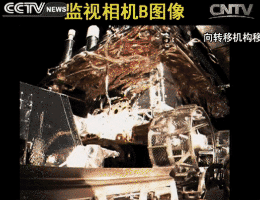
Subscribe to:
Post Comments (Atom)
ESOTERIC
Pf., clique no símbolo do YouTube e depois no quadrado pequeno, em baixo, ao lado direito para obter as legendas CC, e escolha PORTUGUÊS
What time is Around the World?

AND YOU AND I - click image

JAIL THE BANKERS

FEBRUARY 7, 2013 - 7:00PM EST

T O R O N T O
No comments:
Post a Comment